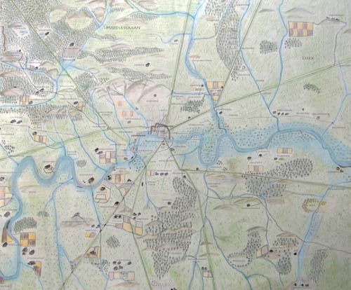
Many English villages, hamlets and farmsteads names go back to Anglo-Saxon times. The Anglo-Saxon map of London below (created by Matt Brown of The Londonist), shows many names that are still part of modern London today.
Please click the Subscribe button below and then choose whether you would like to take out a Monthly or Annual Membership plan.

ARCHI is a unique interactive mapping system and worldwide database of archaeological, historic, and cultural site GPS location data. Technically speaking, ARCHI can be thought of as a geospatial intelligence platform, providing contextual insights by layering text-based data analysis (eg archaeological reports, old maps, historical records) with visual and spatial data.
The revolutionary ARCHI search engine features a variety of visual historical and geographical research aids, including LiDAR, old maps, terrain maps, aerial photography, and Elizabethan, Georgian, and Victorian maps helping users visualize the sites' locations in their historical and geographical context. The UK database alone contains information on more than 200,000 British Archaeological Sites.
Over the years, ARCHI has proved to be an unparalleled powerful resource and Go To website for the identification of unidiscovered archaeological and historical sites by metal detecting researchers, local historians, old map lovers, students, and anyone interested in learning more about the rich history of the UK.
In fact, many of the major treasure discoveries unearthed from British soil over the past 20 years have been made by people who used ARCHI for their background research prior to making those discoveries. If you haven't used it yet, try a search now
Designed and built by Chris Kutler, whose resume includes, 18 years' at The National Archives working as an Archival Data Analyst specialising in Historical data collection, transcription, correction and pattern analysis of data. Chris also holds a Master's Degree in Computer Graphics with specialisation in image processing and 3D image development. Chris has been working on the analysis of data from archaeological records since completing his studies in Field Archaeology in 1997. He is continually working on ARCHI as the de facto Archaeological and Historical Predictive Modeling Kit.
The cost of a subscription to the ARCHI UK database of UK and Worldwide Archaeological Sites is £8.25 (ex VAT) per month or make a 50% saving by subscribing annually for £50 (ex VAT). You can subscribe with PayPal by clicking the PayPal Subscribe button below. If you don't have a PayPal account, the set-up process is very quick and easy and you will have immediate access to all the upgrade features mentioned below. Alternatively, you can send a cheque (see below).
Please click the Subscribe button below and then choose whether you would like to take out a Monthly or Annual Membership plan.
The ARCHI service is used by a wide range of people for a wide range of purposes. From world-renown academic institutions such as Princeton University to Metal Detectorists, Field Walkers, Ramblers, Local Historians and all sorts of people from all walks of life who share one thing in common - a combination of a love of the outdoors and a fascination with the historical landscape. Here's what some of them have said about the service:
I've only one word for you... LEGEND. The site is one of the BEST resources I've ever had the pleasure of using and I'm super thankful for your superb work.
Thanks Chris, brilliant! It’s such a good site, it really is, I think I will have to take out membership to thank you!
I do have to tell you that using your old Pembrokeshire Map I have cracked a perplexing problem I have had after searching for years. I have found Penglin Mill in the Parish of Minwear at which my 4x ggf was Miller from 1797 to approx 1832. Every map I have looked on did not have the mill which was demolished in 1844. Am absolutely overjoyed.
The resources on the ARCHI website can save the enquirer months of research. There's nothing like it!
I must congratulate you on ARCHI. It's a wonderful resource
Myself and Mo have used ARCHI UK almost since its inception by Chris Kutler many years ago. Obviously its even better today and is an amazing tool for the detectorist, beginner or expert.
A literal treasure chest of information for novice and experienced metal-detectorists alike.
I find ARCHI fascinating, looking at the old maps and the related archaeology to where I live and other places I'm interested in.
I use the ARCHI website to note archaeological sites in an area when I'm planning a walk for the Doncaster Ramblers. In fact I've been researching such a walk today, the main feature being the mesolithic site at Deepcar. In other words, I love the site!.
By taking out a membership, your search results will be enhanced with the GPS co-ordinates of all sites in the ARCHI database together with a distribution map of all the sites from your search. This has been designed to enable you to quickly see the archaeological and historic hotspots in your areas of interest.
Further, the GPS co-ordinates of the sites shown from your search plus LiDAR, aerial photographs and modern road maps showing the position of the site on the ground are given. You will also be able to view the location of the site on older maps (19th Century, mid-20th century) - invaluable it you want gain a deeper understanding of the historical landscape in the area of the site.
The precise locations (as GPS co-ordinates and marked on maps) of tens of thousands of Prehistoric, Roman, Iron Age / Celtic sites, Bronze Age, Saxon and Medieval sites and later sites are listed in the UK database. Plus there are links to road maps and aerial photographs showing the location of the sites on the ground. Membership is not required to see a selection of old maps and what has already been discovered in your area. Becoming an ARCHI subscriber will tell you where it was found and give you access to more detailed maps of these sites.
Many beautiful and historically significant coins & artefacts and previously unknown ancient sites have already been found and reported by field walkers and metal detectorists who have used the ARCHI iUK database for their research. By subscribing to ARCHI UK you automatically gain quick and easy access to information on more than 200,000+ UK archaeological sites. Each record includes the map reference (co-ordinate) of each site with a link to a road map and an aerial photograph.
In addition, the database also holds data on archaeologically significant field names and place-names from historical records such as the Tithe Apportionment lists and ancient documents. It is believed that ARCHI UK is the only database where this information can be searched via Postcodes, Places and Co-ordinates and accessed within an archaeological context.
The ARCHI UK database (Archaeological Sites Index) contains details of sites mentioned in rare books and archaeological reports / surveys which are not easily found outside specialist libraries.
The 200,000+ UK archaeological sites listed in the ARCHI UK (ARCHI UK) database come from published sources such as hundreds of archaeological reports, county archaeological journals, findspots reported by archaeologists, fieldwalkers and metal detectorists and treasure hunters who have previously reported their finds while treasure hunting. The data from a search links to aerial photographs of sites enabling you to view many fascinating cropmarks and pinpoint the exact locations of the sites recorded in the database on the ground. The field-name data is of special interest because it can lay the ground for the discovery of previously unknown historic and ancient sites and further our knowledge and understanding of Britain's history.
There is continuous work on the development of new technical features designed to further simplify the the identification and location of existing and new archaeological sites in the UK.
Further, every record is has direct links to an aerial photograph, a local road map showing the position of the site and also to a 19th Century Map showing the area of the site as it was.
Note that public access to this database is not available anywhere else. Also, you will be able to gain access to any new information for one year when it is added to the database for no extra cost.
ARCHI is a Natural Language Processing (NLP) system integrated with a map-based data visualisation platform. It has been in development since 1999. Over time, it has evolved to integrate different data sources and technologies. The core components of ARCHI are the ARCHI Geo-spacial Search Engine, which processes and analyze natural language data, including archaeological or historical documents, reports and records and layer this information with visual and spatial data including LiDAR and old historic maps.
The current iteration of ARCHI integrates natural-language processing with a broad suite of land, property, environmental and geospatial datasets. While ARCHI began life in an archaeological context, over the past 25 years' it has found extensive applications right across the spectrum but in summary it is now used extensively by both professionals and hobbyists to understand land characteristics, development constraints, site history, and environmental conditions, which are all relevant to planning, land-use assessment, property and, of course, archaeological research:
Users rely on this information when considering:
These are all areas that feed into early-stage planning decisions and property assessments.
Through this integrated geospatial and environmental approach, ARCHI functions not only as an archaeological resource but as a widely used land-information platform supporting enquiries about property, planning constraints, site history, environmental risk and development suitability.
The end result of combining the NLP output from the published documentary record with map layers has been designed to enhance our understanding or meaning of the natural language data, by giving users geographic or spatial context to data reference associated with spatial data in natural language expressed as text. For example, a site described in archaeological reports processed by the NLP can be visualized on a map, enriched by topographical and historical details from the geospatial layers.
In essence, ARCHI is more than just an NLP system though; it acts as a geospatial intelligence platform, providing contextual insights by layering text-based analysis with visual and spatial data. This integration makes it easier for users to explore connections between written descriptions (processed by NLP) and real-world geographic locations.
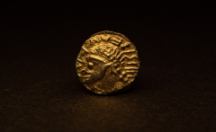
Anglo-Saxon Gold Coin Finds (2021)
The following articles on the theme of Metal Detecting and Community Archaeology have been published:
Unearthing the Past Using Farm Field Names (Tithe Maps)
Using Maps to Find Undiscovered Ancient Sites
Connecting with our Ancestors: June 2011
Metal Detecting as Community Archaeology: Enabling citizens to discover their own heritage: December 2010
See the ARCHI Frequently Asked Questions (FAQ) if you would like to read more on our:
ARCHI is an internet-based service. If you would like to contact us, of if you have a query about the ARCHI website you may find the answer on our Frequently Asked Questions (FAQ) page.
ARCHI is an web-based only service. If you wish to contact us, please click one of the following options and send a message with details of your query. Please bear in mind we are a small business with limited resources but we still aim to respond to your query within 3 working days. However, in practice our response time is usually much sooner.
If the answer to your query isn't there, you can also email us from the FAQ page. At the top of this page there will be a list of subjects your message may fall under. Just click the relevant link relating your subject and this will automatically categorise your message so that it will be handled more efficiently.
If your query is not in any of the categories listed then just click the last entry, which will be for 'general' enquiries.